
Circumambulation of Powell Plateau - continued
To Bedrock Rapid
Descend Stone Creek on the easy trail on the upriver side. [We take a few moments to go back up below the falls and here I manage to slip on a rock and nearly submerge one of my precious cameras. To reduce the risk of damage to the film, I suck air out of the slot for the winder. George teases that it's the first he's seen anyone try to use a camera for a canteen.]
Follow the riverbank. The riverbank may cliff out at high water; go all the way up if you must go up at all. [The water is too high to follow the bank and so we move up uncertainly through broken, black cliffs seeking a favorable route. Gary explores and then we follow. One spot is a narrow crumbly ledge where I crawl and my pack bangs overhead. George has the boot on his right and tennis shoe on the left and uses that boot to advantage, finding a few easier steps closer to the cliff.]
Camp 3 was a beach halfway between Stone and Bedrock. [George has a love for beach camps and always washes up at the end of the day. The narrow strip of sand runs shallow into quiet water, so we all do the same. The light is going just as we finish dinner in a group. It must have been quite a big meteor coming out of the west. The whole group but me says "Aahh!!!" Facing east, with my back to the spectacle, I can see my shadow outlined on the sand in front of me for about 3 seconds.]
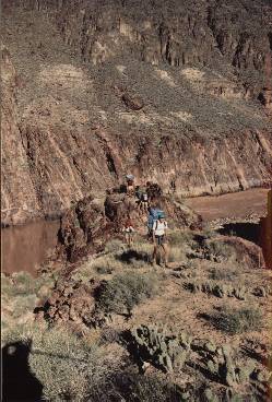
Low cliffs again block the bank and then drop down to form a bench downriver from Bedrock. Go along the top and then down an unlikely zigzag crack into the bed of Bedrock.
To Fossil Rapid
Go up the upriver nose from Bedrock over slick, pink rock.
 Ascending the downriver nose of pink granite to follow this rising bench toward Switchlevel Canyon. |
Climb to the bench and follow the rising slope to the next canyon ("Switch-Level"); good water here. [Each time we leave a spot we get the word from George how much water he thinks we should carry and there is never a problem.] Continue south to gain the Tapeats rim. From here to 128 Mile is broken up in spots. Some sections of this are rugged and slow; the group split and we went high with George. The descent to the bed goes down the obvious talus ravine well into the canyon and continues down an unlikely, but easy, Tapeats fall to the bed. Good water; not much room. Exit up the ravine directly opposite; steep and rocky.
Follow easy, gradually-descending Tapeats rim to 127 Mile. You can climb down the downriver nose; lower packs, be careful. The first ravine up into 127 Mile is probably easier and safer. This was Camp 4. [Camp routine rotates cooking duties in pairs and Marcey is my partner. She handles most of the cooking and I handle most of the cleaning, but usually feel as if I'm doing less than my share. Evening meals are dehydrated and and easy to prepare, and although it always seems that there is a lot of food, nothing ever remains. Breakfasts are the most aggravating event as I am not a natural early riser, but George's schedule is specific. Hiking starts at 7AM, so breakfast is at 6AM, so cooking and coffee starts at 5AM.]
Follow the bank upriver and go up the next side-canyon to the Tapeats rim. Contour the easy, gradually descending Tapeats rim to the bank below Fossil Rapid. [At one point someone in the group gives a caution to someone walking on a ledge of Tapeats that it might not be secure. This gets a chuckle because we are probably walking across places like this all the time, most often without noticing or realizing it. Actually, it is risky. In these remote places where hikers don't often go, there are loose rocks and bad holds everywhere.] Downriver from Fossil the beach camp at Randys Rock is accessible from the Tapeats. The river channel gets wider as the Tapeats goes under. At low water, we continued upriver along the bank, but it might be wet at high water.
To Blacktail Canyon
At the next ravine upriver from Fossil is a large travertine formation (cemented riverine deposits) not distinguished on the Geologic Map [older version]. There are game trails going up before the ravine, but we all missed the hint. After attempting to go along the bank, each of us gives up separately and then we all go off in search of 10 different ways to go up. It looks like it should be easy to climb onto the top of the travertine before this ravine. Then stay high on this slope until the next big ravine; then go back to boulder-hopping along the bank.
The shore opposite Forster Canyon probably cannot be walked at any water level. The debris from Forster pushes the river into the opposite wall (our side) and the bank is eroded. Go up and follow a narrow track on a ledge 25 feet above the rapid. It looks like there could be a higher bypass. Camp 5 at Mile 122. (Note: Later information from the film "River of Stone": Near Mile 122 a set of stone steps from the river to ledges in the Tapeats are believed to be the only remaining sign of the Powell explorations.)
[We could have pushed on farther today, but stop a little earlier than usual, seduced by a large beach with nice shallows for wading and washing. Events at Stina have put us a a half-day behind schedule. We've made up some time, but not enough. The next section of the route has to be timed for travel at the right hour, with the right destination, and we are not going to make our window, so there is no point in pushing on.]
Upriver from 122 Mile Canyon the Tapeats formation begins to rise above river level again. There is a very good track well upslope from the river and this section can go very fast. At Blacktail Canyon the track continues around the point into the canyon. Presumably there is a high route along the Tapeats through Blacktail. The ravine into Blacktail from the downriver side drops off into the narrows, which is worth going down to see; it is an easy climb down the downriver nose to the beach. There is a nautaloid fossil on the face of a limestone block up in the canyon. [We have a leisurely lunch, go up into the narrows to see the nautaloid, and dig up a six-pack of beer that Bob placed during a recent raft trip.]
Catalog of Places - Trips - Routes - Notes