| Rock Garden - Grand Canyon Routes | |
|
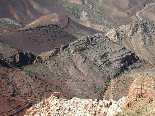
Exploration of Nankoweap Mesa, 07 Oct 2010 The Route Start from streamside base-camp at Butte Fault (Two Springs) where Tilted Mesa Trail ends. Go upstream a short distance just past the dark basalt outcrop constricting the creek at the fault. Along the sharp bend of Nankoweap Creek look for a faint track going up a steep minor ravine onto the ridgeline of a red earth slope which is the upstream bank of the larger drainage. This was once a mining trail going up to digs in the upper ravine adjacent to the Butte Fault. Unfortunately, disuse and blackbrush have largely reclaimed the trail. The first objective should be the high southern saddle crossing the vertical limestone upthrust and giving access to the major drainage that heads in the middle of Nankoweap Mesa. The route tops out at the narrow break dividing the north and south sections of the mesa. An early start will allow you to reach the top mostly sheltered from the rising sun. Butte Fault Saddle Photo view from the top shows the saddle. This easy saddle is a significant gain in elevation taking about 1.5 hours from camp. If you want to find the mine dig, make a note to descend the ravine adjacent to the Butte Fault escarpment on the return trip, and from the mine then go up and cross over the ridge above the mine and reenter the blackbrush valley area since the ravine is not a descent route, and from there look for the old trail back to the streambed. Primary Lower Ravine After a steep descent east of the fault a faint track exists from dayhikers going for the Mesa. Stay west of the bed approaching the main ravine and climb up the next level before entering the bed where it starts the bend that leads into the ascent ravine. The bed gets steeper in the Supai cliffs with larger obstacles forcing diversion onto the north slope. This is rugged travel but there are no real obstacles. Above a very minor upclimb at the top layer of red Hermit shale the slope eases briefly. This slope area is stable at the base of the Coconino rubble where the slide above covers most of the slope. Continue ascending the slide on a faint track until solid rock appears again. The slope straight above looks open and passible but this is not the route. Ascend an easy minor ravine to the right. The top of this ravine is a level area with a cairn assuring you are on-route. The headwall of this intermediate ravine is an obstacle and is also not the route. Minor scrambling (no real climbing) is required to ascend the easiest way up over fractured sandstone that forms the east wall of the ravine and onto the hump with a view of the big ravine that takes you to the top. Upper Fault Bay The route may look doubtful and the sandstone surfaces offer no sign of use or travel. Traverse level right and follow an easy slope with a faint track and a few more cairns leading into the big ravine complex which goes to the summit. At this point be sure to look back where you have just come to recognize the return route more clearly. Cross the first ravine to the next break and ascend the ledge to the next level. Then contour left following a faint track going back up to the middle of the primary ravine. Rock rubble in this section of ravine is large enough to be stable, but progressively smaller, steeper, and less stable going up. Take care not to roll loose rocks on hiking companions if anyone is reckless enough to join you on this trek. The climb from camp to the top was accomplished in 4 hours — you may be faster or slower. Mesa Ecology and Topography The top of the ravine is the narrow neck of a fault break that separates the north (lower) and south (upper) areas of the mesa top. The high point is at the south end overlooking Kwagunt Creek and the effort getting up here is worth investing some time on top. Proof that the route is a viable deer track can be found from the occasional droppings near some of the junipers on the upper plateau. Vegetation on top forms a variety of cooperative plant groups to retain rainfall and nutrients in the fragile soil. Enduring drought seems to be the normal condition of life. Water I made this hike just after 2 days of almost continuous rain and there was some water in the ravine west of the main fault but none on the route up. Difficulty The terrain is complex and there is considerable elevation — more than 2,000 feet if you include the up-and-down crossing Butte Fault. This is a difficult route and some have attempted this and not found the way up. The critical part is the Coconino traverse section making a zigzag connection between the lower and upper segments. It is possible to get somewhat off-route and still get up to the top with minor climbing. It's also possible to get confused and cliffed out, or an injury from unstable or rolling rock. Typical of steep off-trail routes there is not much holding things in place. Appeal Definitely a trophy ascent although not technically difficult. The view is awesome (yes, I mean that literally). |
|
|
Catalog of Places - Trips - Routes - Notes |
|